Introduction to Stormwater Permits

Introduction to Online Stormwater Permits

div class=”four-by-three”>

Residential Stormwater Permits

Agriculture Stormwater Permits

What to Bring For a Stormwater Permit?

This questionnaire is designed to help you through the process of getting a Stormwater Permit. It will alert you to what documentation you will need to obtain before you make a trip to the office.

  • Not all permits require fees.
  • You will need to complete a Stormwater Permit Application with a signature.
  • Some permits may allow the contractor to sign.

Pay attention to the summary at the end of the questionnaire for what documents you will need to obtain.

In addition to completing the questionnaire above, you are encouraged to watch the 3-part In the Know Video series on the stormwater permit process. The videos provide an overview of why a stormwater permit is needed and what documents and information you need before you start the stormwater permit process.

Stormwater Permit Office Hours

Monday, Wednesday, and Thursday from 8:00 a.m. to 12 noon.

Continental Divide Tour

When you click “Get Directions” on the map below, you can start exploring the Continental Divide by following three easy steps:

  • Enter the address of where you wish to start
  • Select where you want to start your tour, i.e. on the upper left, upper right, lower top or lower bottom of the Continental Divide
  • Click on “Get Printable Directions”

You are provided with step-by-step directions and are ready to start your tour. If you wish to print the directions out, click on “print.” If you want to return to the Continental Divide home page click on the “X.”

If you wish to use your GPS to navigate the tour, go back to the tour home page and click on each point to see the latitude and longitude to guide you on your tour. Also, if you click on each point, you will be told approximately where you are and points of interest you will find in the vicinity.

Use your mouse to zoom in or zoom out or use the “+” and “-” buttons found in the upper left-hand corner of the map.

Take a Drive on the Continental Divide

One of America’s favorite past-times is to take drives that allow us to enjoy beautiful scenery at a leisurely pace while discovering new places and returning to favorite places. With this is mind, we’re sharing a Drive-It-Yourself Tour of the Continental Divide within Richland County. The purpose of this tour is to highlight one of the unique aspects of our county’s natural resources. This is a drive you take when convenient for you and at your own pace.

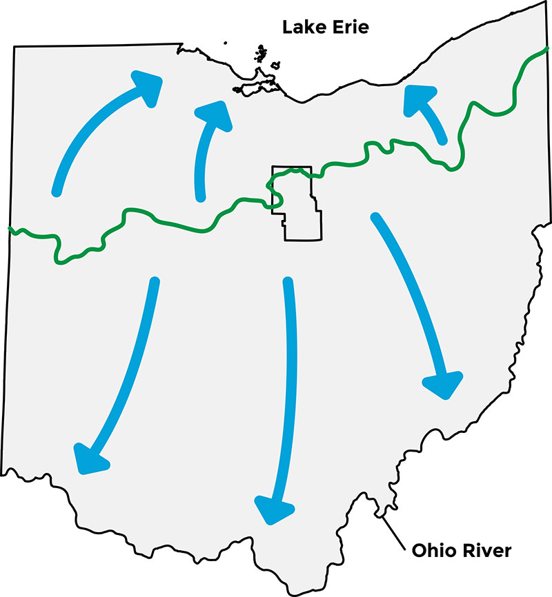
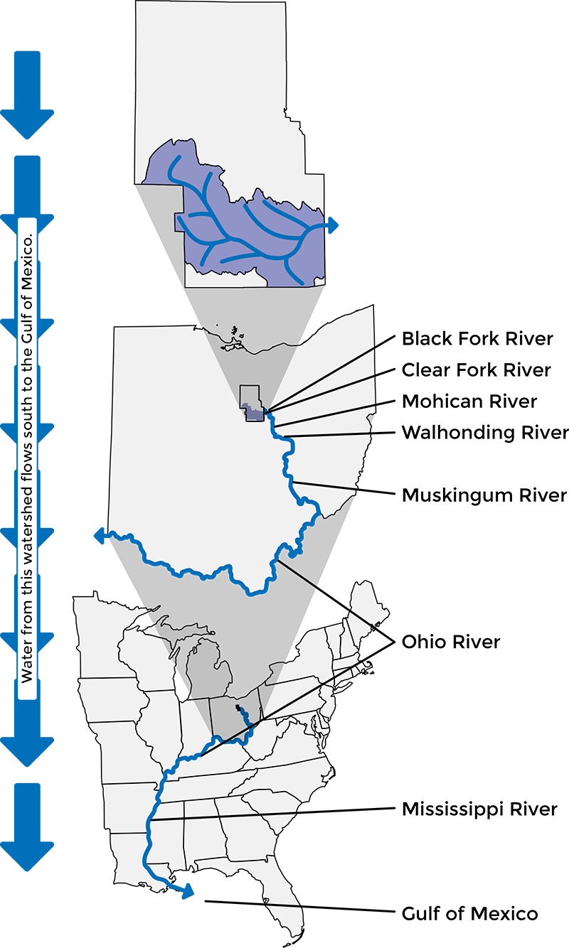
Let’s back up for a minute, though, and explain what the Continental Divide is. The Continental Divide is a major watershed boundary. On one side, the water flows to Lake Erie, and on the other side, water flows to the Ohio River. Many people are accustomed to thinking the Continental Divide follows the highest point of a region. However, when you’re traveling the Richland County portion, you may find yourself at a spot that is lower than hills you see in the distance. Your eyes aren’t deceiving you. The distant hills are isolated areas within their watershed.

As you travel through Richland County, we hope you will continue to be awed by its beauty and diversity and perhaps make some new discoveries. Send us a photo of yourself on the tour along with the date and location, and we’ll share it on our social media outlets.

Take your time and enjoy your drive on the Continental Divide!

Stormwater Pre-Permit Request Form

A 48 hour notice is required PRIOR to any earth disturbing activity and also upon project completion.

PLEASE CALL 419-747-8686

General Site Responsibilities

As a property owner, you are responsible for all earthmoving activities on your property. The application for a Storm Water Permit Application is conditional. This means that based on the information submitted, you are required to follow the items indicated on the drawing, such as silt fence, diversions, temporary seeding, straw bales, etc. We have in the office pamphlets and publications to assist you on installing these practices if needed. A site investigation will be done prior to and during construction. Any additional site changes will be made to you in writing. This permit application gives permission for a representative of the county to make routine on-site inspections and evaluations at any given time. Always, before putting a shovel in the ground, call the Ohio Utilities Protection Service (OUPS) for location of utilities toll free 1-800-362-2764.

(Even mailboxes and sign posts can sever telephone, electric and television cable or gas line.)

The following are items that must be addressed on any new site:

  1. The drive entrance is the first priority and shall be constructed prior to any earth disturbing work to prevent silt, dirt or debris from entering the roadway. It shall have sufficient stone or gravel to allow for delivery of building materials and contractors use and maintained through the life of the project. The discharge of water onto a public road must be limited
  2. A sign or mailbox bearing the house number shall be erected as soon as this permit is granted. This aids us and other agencies in locating the site as well as emergency services if the need should arise.
  3. Inspections will be made on a regular basis during construction and will formally begin once the owner calls us 48 hours prior to construction. Access shall be available during normal working hours of 8:00am to 5:00pm Monday – Friday for inspections and reviews until the permit has been finalized. If any corrections are required, the owner will make the corrections directly or order their excavator or an appointed person that has been approved to do so in a timely manner.
  4. Once the earth moving and final grade has been established, you are required within 7 days to complete seeding and mulching of those areas. This is a critical time due to the loose soil conditions and the vulnerability to erosion.
  5. The permit application will become the actual permit once all signatures have been made.
  6. The permit requires strict adherence to regarding sub-surface drainage as permitted by law per Ohio Revised Code 307.85 located within the Richland County Stormwater and Sediment Control Regulations. In the event any sub surface tile are unearthed, damaged or located in such a fashion that it would interfere with construction, excavation is to cease and our office notified. It will be the responsibility of the owner to present a plan in writing to make such alterations and repairs as to not impede the flow of water or to re-direct it. It must have the approval of the Richland County Drainage Engineer before any changes take place.
  7. Any silt fence required on the site is required to be trenched in 6” and staked firmly in the ground.

Construction Implementation Schedule

All items listed below are required to be inspected and maintained throughout the construction process.

BEFORE GRADING

  • Install Silt Fence. It Shall be Cleaned of Accumulated Sediment When Approximately Fifty Percent Filled.
  • Install Storm Sewer Inlet Protection.
  • Construct Construction Entrance. Top Dressing May Be Required As Conditions Demand.
  • Construct Diversion, Sediment traps/Basins.

SITE GRADING

  • Begin Site Clearing and Grubbing Operations.
  • Begin Overall Site Grading and Topsoil Stripping.
  • Establish Topsoil Stockpile, Install Silt Fence And Cover Or Vegetate Stockpile.
  • Disturbed Areas Where Construction Will Cease For More Than 7 Days Shall Be Temporarily Stabilized.

UTILITIES

  • Construct Staging and materials Storage Area.
  • Install Utilities.

BUILDING

  • Construct Temporary Concrete Washout.
  • Begin Building Foundation and Structure Construction.
  • Install gutter, Curbs And Pavement.

FINAL STABILIZATION AND LANDSCAPING

  • Provide Permanent Stabilization For All Remaining Disturbed Areas.
  • Remove or Convert Temporary BMP’s and Stabilize All Areas Disturbed By Their Removal.
  • Monitor Stabilized Areas Until Final Stabilization Is Reached.

Videos

If you are thinking about a construction project in an unincorporated area of Richland County or the Village of Lexington, you are encouraged to watch the 4-part In the Know Video series on the stormwater permit process. The videos provide an overview of why a stormwater permit is needed and what documents and information you need before you begin the stormwater permit process.

Introduction to Stormwater Permits

Introduction to Online Stormwater Permits

Residential Stormwater Permits

Agriculture Stormwater Permits

What to Bring For a Stormwater Permit?

This questionnaire is designed to help you through the process of getting a Stormwater Permit. It will alert you to what documentation you will need to obtain before you make a trip to the office.

  • Not all permits require fees.
  • You will need to complete a Stormwater Permit Application with a signature.
  • Some permits may allow the contractor to sign.
  • Permit office hours are Monday, Wednesday, and Thursday from 8:00 a.m. until 12 noon and by appointment outside of permit office hours.

Pay attention to the summary at the end of the questionnaire for what documents you will need to obtain.

In addition to completing the questionnaire above, you are encouraged to watch the 3-part In the Know Video series on the stormwater permit process. The videos provide an overview of why a stormwater permit is needed and what documents and information you need before you start the stormwater permit process.

Stormwater Permit Office Hours

Monday, Wednesday, and Thursday from 8:00 a.m. to 12 noon and by appointment outside of permit office hours.

Introduction to Stormwater Permits

Residential Stormwater Permits

Agriculture Stormwater Permits

Upper Olentangy Watershed

Note: Impervious surface permit icons, land use icons, and livestock icons do not necessarily indicate exact locations. They are approximate locations on the same land parcel.

UPPER OLENTANGY Begins in Sandusky Township → Delaware Reservoir → Olentangy River → Scioto River → Ohio River → Mississippi River → Gulf of Mexico

Soil Type in the Upper Olentangy Watershed

  • Fitchville-Luray-Bennington
  • Pewamo-Bennington
  • Rittman-Wadsworth
  • Bennington-Cardington
  • Wooster-Canfield

Impervious Areas

Total Impervious Areas Created in the Upper Olentangy Watershed*   127,831 sq. ft.

Residential Permits

(Homes, Pole Barns, Additions, etc.)

PermitsYear
Least Area Created0
sq. ft.
Multiple
Most Area Created36,596
sq. ft.
2004
Exemptions**

(Less than 2,000 square feet created)

PermitsYear
Least Area Created0
sq. ft.
Multiple
Most Area Created1,584
sq. ft.
2009
Commercial Permits
PermitsYear
Least Area Created0
sq. ft.
Multiple
Most Area Created26,136
sq. ft.
2009

*This figure does not include impervious areas from prior to 2000
**Agriculture is included in permit exemptions

Impervious Areas Created in the Upper Olentangy Watershed by Year

Upper Kokosing Watershed

Note: Impervious surface permit icons, land use icons, and livestock icons do not necessarily indicate exact locations. They are approximate locations on the same land parcel.

UPPER KOKOSING Begins in southern Richland County, west of Butler → Kokosing Lake → Walhonding River → Muskingum River → Ohio River → Mississippi River → Gulf of Mexico

Soil Type in the Upper Kokosing Watershed

  • Shoals-Chili-Wheeling
  • Fitchville-Luray-Bennington
  • Pewamo-Bennington
  • Rittman-Wadsworth
  • Hanover-Titusville-Loudonville
  • Lordstown-Loudonville
  • Wooster-Canfield

Impervious Areas

Total Impervious Areas Created in the Upper Kokosing Watershed*   321,367 sq. ft.

Residential Permits

(Homes, Pole Barns, Additions, etc.)

PermitsYear
Least Area Created0
sq. ft.
Multiple
Most Area Created45,370
sq. ft.
2002
Exemptions**

(Less than 2,000 square feet created)

PermitsYear
Least Area Created0
sq. ft.
2008, 2011
Most Area Created6,696
sq. ft.
2012
Commercial Permits
PermitsYear
Least Area Created0
sq. ft.
Multiple
Most Area Created17,249
sq. ft.
2004

*This figure does not include impervious areas from prior to 2000
**Agriculture is included in permit exemptions

Impervious Areas Created in the Upper Kokosing Watershed by Year

Clear Fork Watershed

Note: Impervious surface permit icons, land use icons, and livestock icons do not necessarily indicate exact locations. They are approximate locations on the same land parcel.

CLEAR FORK Begins in Richland and Morrow Counties → Clear Fork Reservoir → goes through Lexington, Bellville, Butler → joins Black Fork near Loudonville and becomes Mohican River → Walhonding River → Muskingum River → Ohio River → Mississippi River → Gulf of Mexico

Soil Type in the Clear Fork Watershed

  • Shoals-Chili-Wheeling
  • Fitchville-Luray-Bennington
  • Pewamo-Bennington
  • Rittman-Wadsworth
  • Bennington-Cardington
  • Hanover-Titusville-Loudonville
  • Lordstown-Loudonville
  • Wooster-Canfield
  • Cardington-Alexandria

Impervious Areas

Total Impervious Areas Created in the Clear Fork Watershed*   7,423,278 sq. ft.

Residential Permits

(Homes, Pole Barns, Additions, etc.)

PermitsYear
Least Area Created31,949
sq. ft.
2000
Most Area Created711,001
sq. ft.
2003
Exemptions**

(Less than 2,000 square feet created)

PermitsYear
Least Area Created18,272
sq. ft.
2008
Most Area Created54,807
sq. ft.
2015
Commercial Permits
PermitsYear
Least Area Created0
sq. ft.
2014
Most Area Created770,890
sq. ft.
2015

*This figure does not include impervious areas from prior to 2000
**Agriculture is included in permit exemptions

Impervious Areas Created in the Clear Fork Watershed by Year

Black Fork Watershed

Note: Impervious surface permit icons, land use icons, and livestock icons do not necessarily indicate exact locations. They are approximate locations on the same land parcel.

BLACK FORK Begins near Mansfield/Ontario → goes through Shelby → Charles Mill Lake → joins Rocky Fork River east of Lucas below Charles Mill Lake

Soil Type in the Black Fork Watershed

  • Shoals-Chili-Wheeling
  • Belmore-Haney
  • Fitchville-Luray-Bennington
  • Pewamo-Bennington
  • Rittman-Wadsworth
  • Bennington-Cardington
  • Lordstown-Loudonville
  • Wooster-Canfield
  • Cardington-Alexandria

Impervious Areas

Total Impervious Areas Created in the Black Fork Watershed*   5,397,415 sq. ft.

Residential Permits

(Homes, Pole Barns, Additions, etc.)

PermitsYear
Least Area Created7,672
sq. ft.
2000
Most Area Created378,025
sq. ft.
2004
Exemptions**

(Less than 2,000 square feet created)

PermitsYear
Least Area Created18,728
sq. ft.
2008
Most Area Created176,436
sq. ft.
2013
Commercial Permits
PermitsYear
Least Area Created0
sq. ft.
2013
Most Area Created1,066,118
sq. ft.
2004

*This figure does not include impervious areas from prior to 2000
**Agriculture is included in permit exemptions

Impervious Areas Created in the Black Fork Watershed by Year

Rocky Fork Watershed

Note: Impervious surface permit icons, land use icons, and livestock icons do not necessarily indicate exact locations. They are approximate locations on the same land parcel.

ROCKY FORK Begins near Mansfield/Ontario → goes through Mansfield → joins Black Fork River East of Lucas

Soil Type in the Rocky Fork Watershed

  • Shoals-Chili-Wheeling
  • Fitchville-Luray-Bennington
  • Pewamo-Bennington
  • Rittman-Wadsworth
  • Bennington-Cardington
  • Wooster-Loudonville
  • Lordstown-Loudonville
  • Wooster-Canfield

Impervious Areas

Total Impervious Areas Created in the Rocky Fork Watershed*   2,705,851 sq. ft.

Residential Permits

(Homes, Pole Barns, Additions, etc.)

PermitsYear
Least Area Created1,680
sq. ft.
2000
Most Area Created264,353
sq. ft.
2003
Exemptions**

(Less than 2,000 square feet created)

PermitsYear
Least Area Created6,390
sq. ft.
2008
Most Area Created32,448
sq. ft.
2015
Commercial Permits
PermitsYear
Least Area Created0
sq. ft.
2004, 2012
Most Area Created314,885
sq. ft.
2009

*This figure does not include impervious areas from prior to 2000
**Agriculture is included in permit exemptions

Impervious Areas Created in the Rocky Fork Watershed by Year