By Matt Wallace
Field Nutrients and You
Application of nutrients prior to planting is common and may be seen throughout farm fields in Richland County. It is recommended that nutrients be placed on your field and tilled into the soil before you plant. If that can’t be done, apply nutrients once the crop begins to grow. Both options allow for the biggest return on your investment (fuel, time, wear and tear on equipment) and the best chance for waterways to not be polluted.
Placing manure on snow covered, frozen, or rain-saturated ground is discouraged. Nutrients produced on your farm or brought in from other sources can readily leave your farm fields through melting snow or saturated soils. A good rule of thumb is to not apply nutrients when there is a chance of a half inch of rain or more. Winter applications are only recommended if there isn’t any more manure storage space available. In that case, only apply enough to free up the amount of storage space needed.
Additional best management practices include looking for tile blowouts and fixing them before nutrient application. During drier times when soil may be deeply cracked, utilize a tillage implement to close the soil cracks and keep nutrients from directly accessing field tiles.
Setbacks are highly recommended by the Ohio Department of Agriculture (ODA) to keep your nutrients on fields. The recognized setback standards to follow may be found in the United States Department of Natural Resources Conservation Service (USDA-NRCS) 590-CSP-1 document. Click on the link below to access the document, pick up a copy in our office, or request it be emailed. https://www.nrcs.usda.gov/resources/guides-and-instructions/nutrient-management-ac-590-conservation-practice-standard

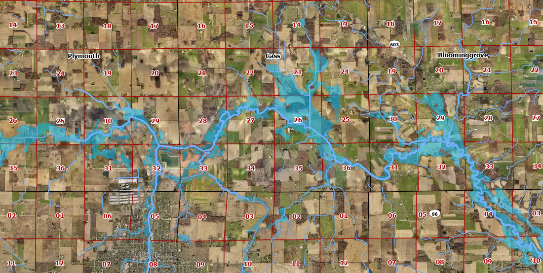
Floodplain 101
What is a floodplain? A floodplain is an area adjacent to a river, stream, or low-lying area that is adjacent to another water body that becomes overwhelmed with water during times of heavy and/or prolonged rainfall or when snow melts. Typically, these areas contain soils that are nutrient rich and identified as being hydric, or very wet.
How are floodplains and maps determined? These unique areas are determined by multiple factors such as topography, soils, proximity, engineering, historic floods, and photographs of historic floods.
Floodplain maps, officially known as Flood Insurance Rate Maps (FIRM), show areas of high, moderate, and low-flood risk which are shown as series of zones. Communities use maps to set minimum building requirements for coastal areas and floodplains; lenders use them to determine flood insurance needs and costs.
Filling and building within the floodplain may come with many challenges which may be costly. Additional requirements for building in a floodplain may include but is not limited to hydraulic/hydrologic studies, additional permits, elevation of entire structures, and additional compaction. These construction standards can influence decisions like “Should I build here? or Should I purchase this property?”.
Each municipality and community has a set of Federal Emergency Management Agency (FEMA) approved regulations for their communities designed to help improve the safety of a community’s residents and plan future development. Regulations vary within Richland County due to each municipality adopting their own regulations. Check the regulations of the municipality under consideration before purchasing or developing property. Richland Soil and Water Conservation District serves as the Floodplain Administrator and Floodplain Manager for Richland County. We encourage you to reach out to us before purchasing or developing a property.
For a location of the flood zones in Richland County, visit https://msc.fema.gov/portal/home.